Back جزيرة موروروا Arabic Mururoa AST Муруроа Bulgarian Moruroa Breton Moruroa Catalan Atoll Mururoa CEB Mururoa Czech Mururoa German Moruroa Esperanto Mururoa Spanish
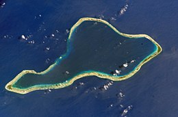
 NASA picture of Moruroa Atoll | |
| Geography | |
|---|---|
| Location | Pacific Ocean |
| Coordinates | 21°50′S 138°50′W / 21.833°S 138.833°W |
| Archipelago | Tuamotus |
| Area | 148 km2 (57 sq mi) (lagoon) 15 km2 (5.8 sq mi) (above water) |
| Length | 28 km (17.4 mi) |
| Width | 11 km (6.8 mi) |
| Administration | |
France | |
| Overseas collectivity | French Polynesia |
| Administrative subdivision | Tuamotus |
| Commune | Tureia |
| Demographics | |
| Population | Uninhabited[1] (2012) |
Moruroa (Mururoa, Mururura), also historically known as Aopuni,[2] is an atoll which forms part of the Tuamotu Archipelago in French Polynesia in the southern Pacific Ocean. It is located about 1,250 kilometres (780 mi) southeast of Tahiti. Administratively Moruroa Atoll is part of the commune of Tureia, which includes the atolls of Tureia, Fangataufa, Tematangi and Vanavana. France undertook nuclear weapon tests between 1966 and 1996 at Moruroa and Fangataufa, causing international protests, notably in 1974 and 1995. The number of tests performed on Moruroa has been variously reported as 175 and 181.
- ^ "Population". Institut de la statistique de la Polynésie française. Archived from the original on 29 March 2020. Retrieved 9 October 2014.
- ^ Young, J.L. (1899). "Names of the Paumotu Islands, with the old names so far as they are known". Journal of the Polynesian Society. 8 (4): 264–268. Retrieved 7 January 2015.
© MMXXIII Rich X Search. We shall prevail. All rights reserved. Rich X Search
